www.RiverBollin.info
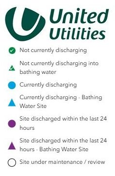
Storm Overflow Map Icons
| Home | Report a Problem | Pollution Journal | Sewers & Drains | The Sewage Works | Farm Run-Off | Invasive Species | How to Help | Who's Involved | River Facts | River Jargon |
It is a good thing that most water companies have now published maps showing the 'almost live' status of their storm overflows. People can now avoid using the rivers at inappropriate times. List of Maps
But the symbol colours seem to have been chosen to avoid causing alarm.
Only Thames Water uses this obvious green/amber/ red combination:-